Estimation of the sediment runoff range due to heavy rainfall on September 5, 2023 -Around the Thessaly region in central Greece–
Change log
Created on September 11, 2023
Published on October 18, 2023
Contact person
Storm, Flood and Landslide Research Division: Hiromi AKITA and Satoshi IIZUKA
Summary
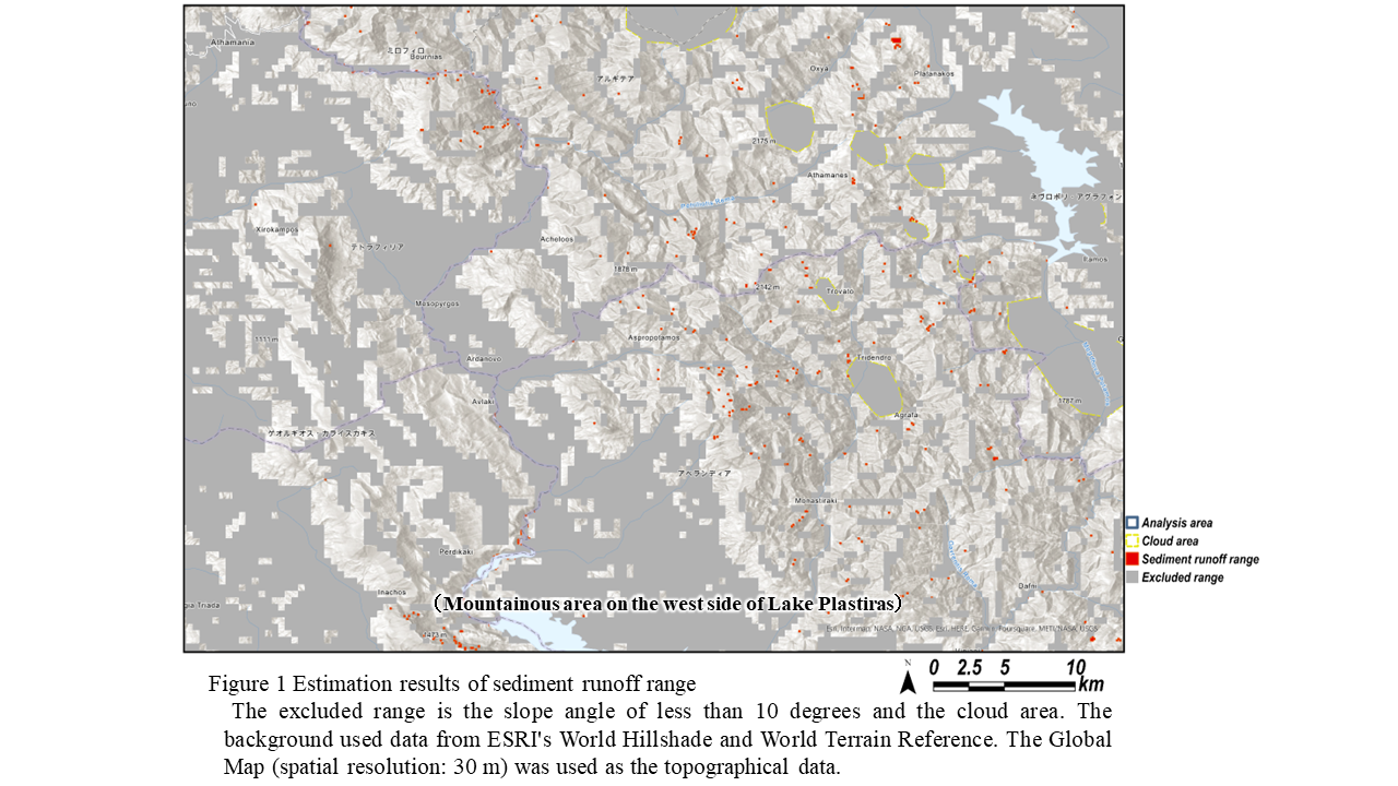
In Greece, the Mediterranean Tropical Cyclone “Daniel” on September 5, 2023 caused heavy rainfall reaching several hundred millimeters in 24 hours, causing floods and landslides. National Research Institute for Earth Science and Disaster Resilience (NIED) is developing a method to extract the sediment runoff range using satellite data, with the aim of creating information products that support early recovery after disasters. This method is expected to enable a wide-area overview after disasters. We attempted to extract the estimated sediment runoff range around the Thessaly region in central Greece (approximately 22,000 km^2) using optical satellite data before and after heavy rainfall. As a result, we extracted more than 400 locations with the possibility of slope failure or landslide around Mt. Agrafa (approximately 2,800 km2) on the west side of Lake Plastiras (Figure 1). The extraction work was completed within one week after disaster.
Method for estimating sediment runoff range using NDVI difference values
In recent years, cases of sediment disasters such as landslides and debris flows have been confirmed to occur over a wide area. For emergency recovery after disasters, it is necessary to understand the location of sediment runoff and the extent of its impact-area. We are working on developing a method to extract the sediment runoff range in order to provide information for emergency recovery.
Optical satellite data was used for the analysis, and a binarized image was created by setting a threshold for the NDVI difference values (ΔNDVI). Furthermore, the estimated sediment runoff range was extracted using the slope angle.
-Optical satellite data used-
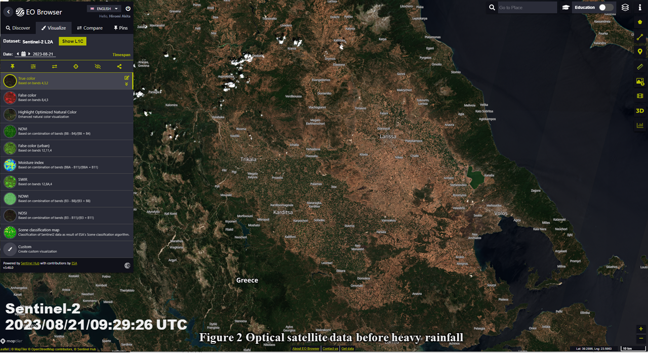
Sentinel-2/MSI (spatial resolution 10 m, L2A)
Before heavy rainfall: August 21, 2023, 09:29 AM (UTC), After heavy rainfall: September 10, 2023, AM 09:29 (UTC)
Figures 2 and Figure 3 show optical satellite data before and after heavy rainfall. After the heavy rains, turbid water was observed in large urban areas such as Larissa in Thessaly region. Furthermore, Figure 4 shows ΔNDVI images created from optical satellite data before and after heavy rainfall. The analysis area was set around the turbid water area, including the mountainous area to the west. Please note that the satellite data used has a spatial resolution of 10 m, so changes in areas smaller than 100 m^2 (10 m x 10 m) cannot be detected. Turbid areas, slope failures, and debris flow areas have large ΔNDVI and appear as white cells.

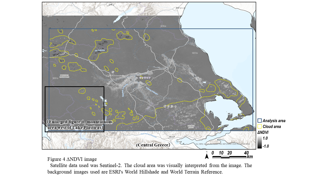
Next, we set a threshold value for the ΔNDVI and extract the range where there is a possibility of sediment runoff. A threshold of 0.25 or higher was applied. In addition, the slope angles in the analysis area were sorted using the Global Map 1). Furthermore, after considering other research reports 2) 3), we determined that the slope angle of 10 degrees or more is the estimated the sediment runoff range. Note that areas covered by clouds are excluded from the analysis.
1) Global map (Geographical Survey Institute of Japan),
2) Manual of Technical Standard for establishing Sabo master plan for debris flow and driftwood (National Institute for Land and Infrastructure Management, Japan. 2016),
3) Debris flow/driftwood countermeasure guidelines and explanations (Forestry Agency Private Forest Department. 2019)